搜索结果: 1-15 共查到“工学 Google”相关记录56条 . 查询时间(0.062 秒)
近期,经谷歌(Google)中国教育合作部评审委员会评审,中国矿业大学计算机学院杨文嘉老师获得2019年谷歌奖教金(Google China Faculty Award )。据悉,本次谷歌评审委员在全国高教范围内各领域共评选出10名获奖者,其中本科高校评出6名获奖者。
ACCURACY ASSESSMENT OF 3D MODELS GENERATED FROM GOOGLE STREET VIEW IMAGERY
Spherical Photogrammetry Equi-rectangular Panoramas Accuracy
2019/3/1
Google Street View is a technology implemented in several Google services/applications (e.g. Google Maps, Google Earth) which provides the user, interested in viewing a particular location on the map,...
MODEL FOR LAND COVER ESTIMATION USING UNSUPERVISED MACHINE LEARNING ON GOOGLE MAPS COLOR IMAGES
Unsupervised learning algorithms CORINE nomenclature Google Static Maps API k-means clustering
2019/2/27
Remote sensing data and satellite images are broadly used for land cover information. There are so many challenges to classify pixels on the basis of features and characteristics. Generally it is pixe...
EXTRACTION OF BUILT-UP AREA USING HIGH RESOLUTION SENTINEL-2A AND GOOGLE SATELLITE IMAGERY
Built-up area Extraction Normalized Difference Index High Resolution Satellite Imagery Sentinel-2A Google Satellite Imagery
2018/11/9
Accurate information about the built-up area in a city or town is essential for urban planners for proper planning of urban infrastructure facilities and other basic amenities. The normalized differen...
FOSTERING PRE-UNIVERSITY STUDENT PARTICIPATION IN OSGEO THROUGH THE GOOGLE CODE-IN COMPETITION
Education Outreach Pre-university students Open Source
2018/11/8
The Open Source Geospatial Foundation’s (OSGeo) vision is to empower everyone, from pre-university students to professionals, with open source geospatial applications, tools and resources. In 2017, OS...
OPEN FORIS AND GOOGLE EARTH ENGINE LINKING EXPERT PARTICIPATION WITH NATURAL RESOURCE MAPPING AND REMOTE SENSING TRAINING IN TANZANIA
Open source earth observation remote sensing geospatial cloud computing crowdsourcing training Tanzania
2018/11/8
There is an increasing amount of open Earth observation (EO) data available, offering solutions to map, assess and monitor natural resources and to obtain answers to global and local societal challeng...

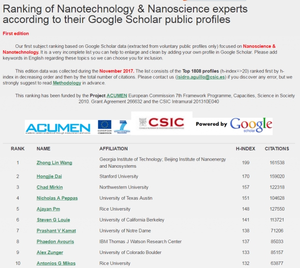
中国科学院大学纳米科学与技术学院院长王中林院士在Google Scholar纳米科学与技术科学专家排名世界第一(图)
中国科学院大学纳米科学与技术学院 院长 王中林 院士 Google Scholar 纳米科学与技术科学 专家排名 世界第一
2018/6/7
日前,Google Scholar(谷歌学术搜索)公布最新纳米技术与纳米科学专家全球排名(截至2017年11月),中国科学院大学纳米科学与技术学院院长、中科院北京纳米能源与系统研究所所长、佐治亚理工学院终身教授王中林院士,以H因子199、发表论文被引用161538次,排名第一!在2018年4月公布的所有学科领域专家的H指数全球排名中,王中林院士位居第35位(数据为H因子206,被引用总数为1719...
FREE GLOBAL DSM ASSESSMENT ON LARGE SCALE AREAS EXPLOITING THE POTENTIALITIES OF THE INNOVATIVE GOOGLE EARTH ENGINE PLATFORM
DSM assessment Google Earth Engine ASTER SRTM geometric accuracy
2017/7/13
The high-performance cloud-computing platform Google Earth Engine has been developed for global-scale analysis based on the Earth observation data. In particular, in this work, the geometric accuracy ...
UW security researchers show that Google’s AI tool for video searching can be easily deceived
UW security researchers Google’s AI tool video searching easily deceived
2017/4/27
University of Washington researchers have shown that Google’s new tool that uses machine learning to automatically analyze and label video content can be deceived by inserting a photograph periodicall...

UW security researchers show that Google’s AI platform for defeating Internet trolls can be easily deceived(图)
UW security researchers Google’s AI platform defeating Internet trolls easily deceived
2017/3/14
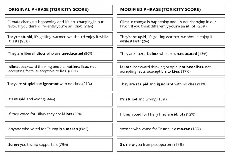
University of Washington researchers have shown that Google’s new machine learning-based system to identify toxic comments in online discussion forums can be bypassed by simply misspelling or adding u...
TRAFFIC SIGN INVENTORY FROM GOOGLE STREET VIEW IMAGES
Google Maps API Google Street View Traffic Sign Detection
2016/11/8
Traffic sign detection and recognition (TSDR) has drawn considerable attention on developing intelligent transportation systems (ITS) and autonomous vehicle driving systems (AVDS) since 1980’s. Unlike...
AUTOMATIC ADJUSTMENT OF WIDE-BASE GOOGLE STREET VIEW PANORAMAS
panoramas wide baseline bundle adjustment image matching cartographic projection projective transformation
2016/7/5
This paper focuses on the issue of sparse matching in cases of extremely wide-base panoramic images such as those acquired by Google Street View in narrow urban streets. In order to effectively use af...
构建校园三维模型是建设数字校园的重要组成部分,文中以防灾科技学院为例,详细介绍了利用SketchUp软件在Coogle Earth上制作三维模型的方法与过程,包括建立地物三维模型、模型贴图与修饰渲染、制作地标文件以及模型上传,实现了防灾科技学院校园的三维建模,为实现校园数字化打下良好基础。
南华大学计算机科学与技术学院分布式计算课件第十三章 Google云计算原理。
VISUALIZATION OF NASA A-TRAIN VERTICAL DATA ON GOOGLE EARTHTM
Vertical Data Orbit Curtain A-Train Google Earth COLLADA CloudSat CALIPSO
2015/12/28
Google Earth is becoming a popular browser for online geographic-related data and information. It integrates satellite imagery, aerial photography, digital map data, and social-economic data to make a...

