搜索结果: 1-15 共查到“Google”相关记录129条 . 查询时间(0.111 秒)
Analysis of Regional Distribution of Tree Species Using Multi-Seasonal Sentinel-1&2 Imagery within Google Earth Engine
multisensor tree species large areas cloud-computing machine learning
2023/12/6
Accurate information on tree species is in high demand for forestry management and further investigations on biodiversity and environmental monitoring. Over regional or large areas, distinguishing tre...
为探明大湄公河次区域植被净初级生产力(NPP)时空变化特征,基于GoogleEarthEngine(GEE)云计算平台,利用MOD17A3HGFNPP时序数据,采用线性趋势分析方法,分析了2001—2019年大湄公河次区域植被NPP的时空变化特征。结果显示:(1)2001—2019年间大湄公河次区域植被NPP总体较高,植被NPP年均值整体上变化趋势不显著,变化波动较大,且与年均温度有显著的负相关性...
近期,经谷歌(Google)中国教育合作部评审委员会评审,中国矿业大学计算机学院杨文嘉老师获得2019年谷歌奖教金(Google China Faculty Award )。据悉,本次谷歌评审委员在全国高教范围内各领域共评选出10名获奖者,其中本科高校评出6名获奖者。

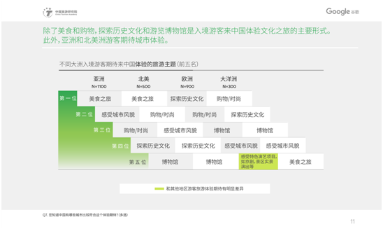
近日,为帮助相关方更好地了解中国入境旅游市场,提振中国入境旅游潜力,我院和Google谷歌携手发布《2019中国入境游游客行为与态度分析报告》(以下简称《报告》)。《报告》指出,在入境游客选择目的地时,自然景观、人文体验和安全是最主要的影响因素,而考虑中国作为目的地时,文化、美食和多样的旅游体验更加突出。美食购物,探索历史文化和游览博物馆是外国入境游客来中国体验文化之旅的主要形式。不同大洲的游客对...
ACCURACY ASSESSMENT OF 3D MODELS GENERATED FROM GOOGLE STREET VIEW IMAGERY
Spherical Photogrammetry Equi-rectangular Panoramas Accuracy
2019/3/1
Google Street View is a technology implemented in several Google services/applications (e.g. Google Maps, Google Earth) which provides the user, interested in viewing a particular location on the map,...
ESTIMATION OF REVISED CAPACITY IN GOBIND SAGAR RESERVOIR USING GOOGLE EARTH ENGINE AND GIS
NDWI Capacity curve Sedimentation Cumulative Capacity Water-Spread Area Google Earth Engine GIS Satellite Data
2019/2/28
Capacity studies of reservoirs are important to evaluate sedimentation and optimize reservoir operation schedule based on realistic assessment of available storage. Capacity study at regular interval ...
MODEL FOR LAND COVER ESTIMATION USING UNSUPERVISED MACHINE LEARNING ON GOOGLE MAPS COLOR IMAGES
Unsupervised learning algorithms CORINE nomenclature Google Static Maps API k-means clustering
2019/2/27
Remote sensing data and satellite images are broadly used for land cover information. There are so many challenges to classify pixels on the basis of features and characteristics. Generally it is pixe...
EXTRACTION OF BUILT-UP AREA USING HIGH RESOLUTION SENTINEL-2A AND GOOGLE SATELLITE IMAGERY
Built-up area Extraction Normalized Difference Index High Resolution Satellite Imagery Sentinel-2A Google Satellite Imagery
2018/11/9
Accurate information about the built-up area in a city or town is essential for urban planners for proper planning of urban infrastructure facilities and other basic amenities. The normalized differen...
FOSTERING PRE-UNIVERSITY STUDENT PARTICIPATION IN OSGEO THROUGH THE GOOGLE CODE-IN COMPETITION
Education Outreach Pre-university students Open Source
2018/11/8
The Open Source Geospatial Foundation’s (OSGeo) vision is to empower everyone, from pre-university students to professionals, with open source geospatial applications, tools and resources. In 2017, OS...
OPEN FORIS AND GOOGLE EARTH ENGINE LINKING EXPERT PARTICIPATION WITH NATURAL RESOURCE MAPPING AND REMOTE SENSING TRAINING IN TANZANIA
Open source earth observation remote sensing geospatial cloud computing crowdsourcing training Tanzania
2018/11/8
There is an increasing amount of open Earth observation (EO) data available, offering solutions to map, assess and monitor natural resources and to obtain answers to global and local societal challeng...

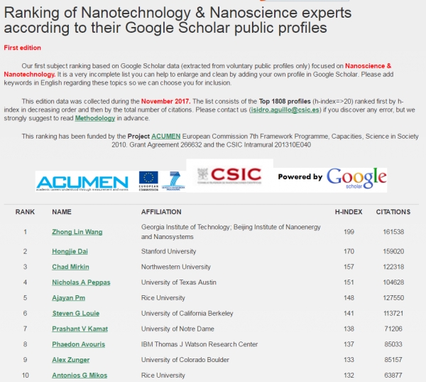
中国科学院大学纳米科学与技术学院院长王中林院士在Google Scholar纳米科学与技术科学专家排名世界第一(图)
中国科学院大学纳米科学与技术学院 院长 王中林 院士 Google Scholar 纳米科学与技术科学 专家排名 世界第一
2018/6/7
日前,Google Scholar(谷歌学术搜索)公布最新纳米技术与纳米科学专家全球排名(截至2017年11月),中国科学院大学纳米科学与技术学院院长、中科院北京纳米能源与系统研究所所长、佐治亚理工学院终身教授王中林院士,以H因子199、发表论文被引用161538次,排名第一!在2018年4月公布的所有学科领域专家的H指数全球排名中,王中林院士位居第35位(数据为H因子206,被引用总数为1719...
COPERNICUS BIG DATA AND GOOGLE EARTH ENGINE FOR GLACIER SURFACE VELOCITY FIELD MONITORING: FEASIBILITY DEMONSTRATION ON SAN RAFAEL AND SAN QUINTIN GLACIERS
Big Data Google Earth Engine Sentinel-1 Glacier velocity field SAR off-set tracking San Rafael Glacier San Quintin Glacier
2018/5/11
The glaciers are a natural global resource and one of the principal climate change indicator at global and local scale, being influenced by temperature and snow precipitation changes. Among the parame...
MONITORING URBAN HEAT ISLAND THROUGH GOOGLE EARTH ENGINE: POTENTIALITIES AND DIFFICULTIES IN DIFFERENT CITIES OF THE UNITED STATES
Google Earth Engine Urban Heat Island Landsat Land Surface Temperature National Land Cover Database
2018/5/15
The aim of this work is to exploit the large-scale analysis capabilities of the innovative Google Earth Engine platform in order to investigate the temporal variations of the Urban Heat Island phenome...
Google 将 AR 和显微镜结合用于癌症检测
ARM 显微镜;癌症检测;光学显微镜
2022/2/21
谷歌利用其在深度学习和增强现实方面的专业知识创造了一些能够在医疗界发挥实质性作用的东西。谷歌已经开发出一种辅助检测癌症的增强现实显微镜(ARM)。尽管目前这台显微镜还是是一个原型,但是谷歌认为它可以帮助世界各地的病理学家加速采用深度学习工具。


