搜索结果: 1-15 共查到“Tropical forest”相关记录33条 . 查询时间(0.081 秒)
Democratic Republic of the Congo Tropical Forest Canopy Height and Aboveground Biomass Estimation with Landsat-8 Operational Land Imager (OLI) and Airborne LiDAR Data: The Effect of Seasonal Landsat Image Selection
Airborne LiDAR Landsat-8 tropical forest canopy height aboveground biomass Congo Basin Forest
2023/12/19
Inventories of tropical forest aboveground biomass (AGB) are often imprecise and sparse. Increasingly,?airborne?Light Detection And Ranging (LiDAR) and satellite optical wavelength sensor data are use...
Tropical Forest Disturbance Monitoring Based on Multi-Source Time Series Satellite Images and the LandTrendr Algorithm
Hainan Island forest disturbances LandTrendr Google Earth engine
2023/11/22
Monitoring disturbances in tropical forests is important for assessing disturbance-related greenhouse gas emissions and the ability of forests to sequester carbon, and for formulating strategies for s...
Exploring combinations of multi-temporal and multi-frequency radar backscatter observations to estimate above-ground biomass of tropical forest
Above-ground biomass Tropical forest Synthetic Aperture Radar Multi-frequency Multi-temporal
2024/2/5
Approaches exploiting the complementary information on forest above-ground biomass (AGB) contained in multi-temporal and multi-frequency radar backscatter have hardly been explored in the tropics. Hav...

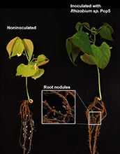
Scientists have discovered an antibiotic produced by a soil bacterium in a Mexican tropical forest that may help lead to a "plant probiotic."Probiotics, which provide health benefits to humans, can al...

Expanding Tropical Forest Spells Disaster for Conservation(图)
expanding tropical forest disaster conservation
2017/9/19
A North Carolina State University study shows that fire suppression efforts in Brazilian savannas turn many of those areas into forest lands, with negative consequences for the plants and animals that...
Can an ancient ocean shoreline set the stage for a tropical forest of today?
ancient ocean shoreline set the stage tropical forest
2017/7/24
Find related stories on NSF's Critical Zone Observatory Sites. Find related stories on NSF's Long-Term Ecological Research Sites.Could an ancient ocean shoreline determine what a tropical forest looks...
ON-LINE CHANGE MONITORING WITH TRANSFORMED MULTI-SPECTRAL TIME SERIES,A STUDY CASE IN TROPICAL FOREST
Multi-Spectral BFAST Dimension Reduction Deforestation Monitor
2016/11/24
In recent years, the methods for detecting structural changes in time series have been adapted for forest disturbance monitoring using satellite data. The BFAST (Breaks For Additive Season and Trend) ...
MAPPING TROPICAL FOREST FOR SUSTAINABLE MANAGEMENT USING SPOT 5 SATELLITE IMAGE
SPOT 5 tropical forest stand volume supervised classification unsupervised classification
2016/11/23
This paper describes the combination of multi-data in stratifying the natural evergreen broadleaved tropical forest of the Central Highlands of Vietnam. The forests were stratified using both unsuperv...
ALOS PALSAR DATA FOR TROPICAL FOREST INTERPRETATION AND MAPPING
Vegetation Interpretation Land-cover Landuse Mapping SAR
2015/12/30
Tropical forest cover is changing in many parts of the World and got attention to the global community since it is one of the main drivers of climate change. Microwave sensor data is useful to monitor...
Averting biodiversity collapse in tropical forest protected areas
biodiversity collapse protected areas
2015/11/13
The rapid disruption of tropical forests probably imperils global biodiversity more than any other contemporary phenomenon1–3. With
deforestation advancing quickly, protected areas are increasingly
...
Tropical Forest Fragmentation Affects Floral Visitors but Not the Structure of Individual Based Palm-Pollinator Networks
Tropical Forest Fragmentation Visitors
2015/11/13
Deforestation is the major cause of fragmentation and spatial isolation of populations in the
tropics [1], with potential to increase species or population extinction rates [1,2]. Despite the
import...
TROPICAL FOREST BIOMASS ESTIMATION AND MAPPING USING K-NEAREST NEIGHBOUR (KNN) METHOD
K-nearest Neighbour Forest Biomass Landsat Map
2015/8/28
Estimation and mapping of tropical forest biomass is important for periodic carbon accounting, as tropical deforestation is one of the
major sources of terrestrial carbon emission in the recent decad...
TROPICAL FOREST MONITORING BY OBJECT-BASED CHANGE DETECTION:TOWARDS AN AUTOMATED METHOD IN AN OPERATIONAL PERSPECTIVE
Deforestation mapping Segmentation Statistical object-based analysis Multidate Remote sensing
2015/8/19
Deforestation still nowadays occurs at an alarming rate in tropical regions. Forest monitoring is required to delineate the extents of deforested areas based on high resolution satellite images (SPOT)...
TROPICAL FOREST BIOMASS MAPPING FROM DUAL FREQUENCY SAR INTERFEROMETRY (X AND P- BANDS)
Interferometer SAR Forestry Land cover Inventory Mapping Modelling
2015/7/30
Radar sensors operating with different wavelengths and polarizations have been widely used for large-scale forest mapping and
monitoring. The interferometric phase obtained by microwave sensors conta...
MONITORING TROPICAL FOREST FROM SPACE: THE PRODES DIGITAL PROJECT
Terrestrial Monitoring Land Use Change Detection Segmentation Classification Forestry GIS
2015/7/29
This paper presents the results of a new methodological approach to identify and to estimate deforested areas. The work refers to the
PRODES DIGITAL PROJECT, which develops an automatic procedure to...

