搜索结果: 1-15 共查到“地球物理学 GNSS”相关记录15条 . 查询时间(0.035 秒)


地球的深内部结构及其运行机制对理解地球起源、演化与动力学过程至关重要,在Science杂志列出的125个最具挑战性的科学问题中排名第10,位列地学研究问题之首。在过去几十年的研究中,地球深内部结构的探测主要依赖于地震仪观测记录。

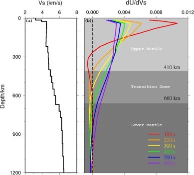
地球的深内部结构及其运行机制对理解地球起源、演化与动力学过程至关重要,在Science杂志列出的125个最具挑战性的科学问题中排名第10,位列地学研究问题之首。在过去几十年的研究中,地球深内部结构的探测主要依赖于地震仪观测记录。地震观测仪器捕获的信号周期越长,信号所采样的内部结构就越深(图1)。随着跨学科交叉研究的推进,高频GNSS这种传统的大地测量观测手段也进入了地震学家的视野, 逐步发展成为跨...

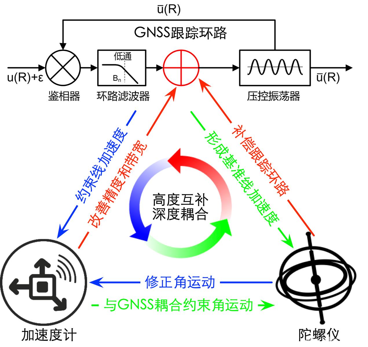
近期,武汉大学卫星导航定位技术研究中心耿江辉教授、张提升副教授课题组破坏性大地震新型观测技术研究取得新进展。他们针对现有强地震观测手段无法完整、准确地捕捉剧烈地表形变的痼疾,率先在国际上提出了深度融合加速度计和陀螺仪的“六自由度GNSS地震仪”原理、方法和仪器原型,攻克了强烈地震时严重损害位移观测精度的幅度和相位畸变难题,为破坏性大地震抵近观测并最终服务于地震预警提供了更为可靠可信的观测手段。成果...
RESEARCH ON THE CRUSTAL DEFORMATION CHARACTERISTICS IN BEIJING USING INSAR AND GNSS TECHNOLOGY
Beijing INSAR GNSS Crustal Deformation Geological structure
2018/5/14
In this paper, we tried to reveal the characteristics of the crustal deformation in both the horizontal and vertical directions in Beijing using InSAR and GNSS observations. Regarding the serious land...
A REVIEW ON LEGAL TRACEABILITY OF GNSS MEASUREMENTS IN THE MALAYSIAN CADASTRAL PRACTICE
Legal Traceability Cadastre Network RTK MyRTKnet
2016/10/14
As the dependency on Global Navigation Satellite System (GNSS) in surveying has been growing over the years, the need for legal traceability of GNSS measurements has become a significant matter. In Ma...
Mitigation of ionospheric effects on GNSS
ionosphere mitigation TEC GNSS positioning radio-occultation
2015/8/28
The effects of the ionosphere remain one of the main factors which limit the precision and the reliability of many GNSS applications. It is therefore indispensable on the one hand to improve existing ...
The sensitivity of GNSS measurements in Fennoscandia to distinct three-dimensional upper-mantle structures
GNSS measurements Fennoscandia three-dimensional upper-mantle structures
2015/1/6
The sensitivity of global navigation satellite system (GNSS) measurements in Fennoscandia to nearby viscosity variations in the upper mantle is investigated using a 3-D finite element model of glacial...
高频GNSS形变波的震相识别:模拟实验与实例分析
实时高频GNSS形变波 振动台模拟实验 强震震例 震相分析 震相识别
2014/10/8
高频GNSS震时形变波震相及识别是GNSS地震学的重要内容.在实时数据处理基础上,本文利用振动台的高频GNSS观测实验,并结合近期部分大震的高频GNSS形变波震相特征进行研究.数据处理结果表明,实时处理与事后处理的精度在同一量级,且与采样率无关.通过与同址观测强震仪和地震计记录的对比及特定震相的频谱分析,发现高频GNSS可完整记录P波、S波、Love波及Rayleigh波震相,影响震相记录的主要因...
实时GNSS地震仪系统实现及精度分析
GNSS地震仪 实时精密单点定位 PANDA软件 海啸预警
2013/11/1
高频GNSS数据实时精密单点定位(RTPPP)可实时获得地表瞬时动态形变和地震波信号,为地震参数快速确定、地震快速响应及海啸预警提供实时的观测资料.本文构建了实时GNSS地震仪系统,主要包括RTPPP和实时探测两部分.利用RTPPP 方法处理了模拟的震动实验平台实验数据和2010年Baja California地震的数据,并与惯导(IMU)、事后PPP和差分相对定位结果比较,定量评估了实时GNSS...
GNSS-R测量地表土壤湿度的地基实验
GNSS-R 土壤湿度 地基实验 土壤介电常数
2011/11/22
应用地基GNSS-R测量土壤湿度,相比空基而言,反射信号接收天线安装位置低,反射区面积小,反射区域内土壤构成成分一致,可以克服空基实验带来的反射区面积大、反射区内土壤地貌复杂的因素,有利于提高反演的精度.本文介绍了地基GNSS-R反演土壤湿度的原理和方法.首先通过归一化处理消除电离层和中性大气对信号强度的影响,然后利用光滑地表散射模型和土壤介电常数模型反演土壤湿度.为验证GNSS-R反演结果的精度...
基于GNSS网络的实时精密单点定位及精度分析
实时精密单点定位 GNSS网络 历元间差分
2010/12/27
基于局域GNSS网络,以历元间、星间差分技术实时估计了GPS卫星相对钟差的历元间差值;针对所估计实时精密钟差的特征,推导了实时精密单点定位的估计模型.对所估计得到的相对钟差的历元间差值、实时定位结果分别进行了比较、分析.结果表明,相对钟差的历元间差值与IGS的最终星历相比其精度可以达到0.08 ns;每小时观测的实时静态定位结果在N、E、U三个方向的精度分别为1.47、3.62、4.09 cm.动...
Simulation of space-borne tsunami detection using GNSS-Reflectometry applied to tsunamis in the Indian Ocean
Simulation space-borne tsunami detection GNSS-Reflectometry applied tsunamis the Indian Ocean
2010/10/20
Within the German-Indonesian Tsunami Early Warning System project GITEWS (Rudloff et al., 2009), a feasibility study on a future tsunami detection system from space has been carried out. The Global Na...
Temperature and Water Vapour Profiling by Carrier Phase GNSS
radiosonde GNSS water vapour temperature profiling
2009/6/9
We propose precise, physically absolute temperature profiling based on use of radiosonde GNSS
carrier phase measurements. This contribution provides some theory development, especially on error propa...


