搜索结果: 1-15 共查到“工学 In Situ”相关记录57条 . 查询时间(0.078 秒)

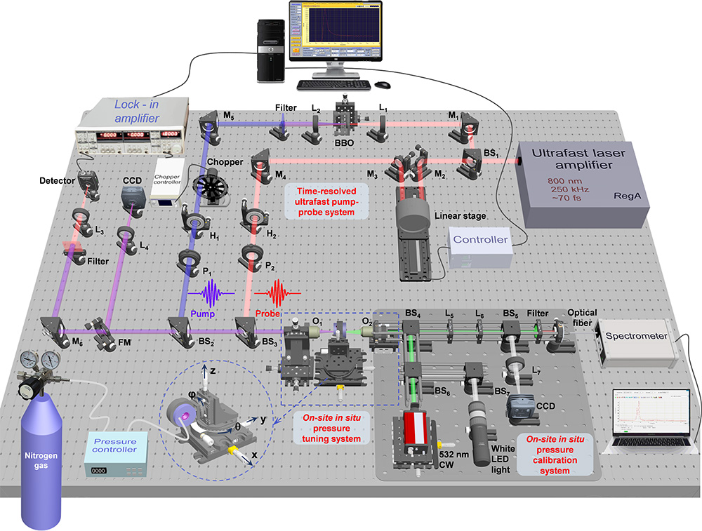
时间分辨泵浦-探测超快光谱由于其独特的优势(如超高的时间分辨率、费米面以上激发态的观测、相干玻色子激发等),被广泛应用于研究各种凝聚态物理(和其它科学),包括高温超导、复杂相变、多自由度耦合、相干调控、激光诱导新量子态和隐态等。高压技术通过直接改变晶格常数来调节电子能带结构和自旋特性等,提供了一种独特、干净的调控手段,也成为凝聚态物理(和其它科学领域)研究的重要手段。近年来,在上述丰富而深刻的基础...
中国地质大学科学技术发展院赵思佳(硕士研究生),周克清*等,工程学院 Available online 25 April 2019,Composites Part A:Applied Science and Manufacturing, In situ fabrication of molybdenum disulfide based nanohybrids for reducing fire hazards of epoxy
层状;二硫化钼;二维纳米;结构;优异
2021/10/20
近日,国际著名学术期刊《Composites Part A: Applied Science and Manufacturing》在线刊发了中国地质大学工程学院周克清副教授团队的研究成果——“In situ fabrication of molybdenum disulfide based nanohybrids for reducing fire hazards of epoxy”。该文第一作者...
STUDY OF THE INTEGRATION OF LIDAR AND PHOTOGRAMMETRIC DATASETS BY IN SITU CAMERA CALIBRATION AND INTEGRATED SENSOR ORIENTATION
Integrated Sensor Orientation Direct Sensor Orientation In situ Calibration Photogrammetry Lidar
2017/7/13
Photogrammetric and Lidar datasets should be in the same mapping or geodetic frame to be used simultaneously in an engineering project. Nowadays direct sensor orientation is a common procedure used in...
2016年动态材料现象的原位电子显微镜技术研讨会(Symposium CM4—In Situ Electron Microscopy of Dynamic Materials Phenomena)
动态材料现象 原位电子显微镜技术 研讨会
2017/2/15
In recent years, in situ transmission electron microscopy (TEM) has been well recognized as a powerful tool for the study of materials dynamic processes. For instance, it has been possible to reveal s...
Estimation of leaf area index using an angular vegetation index based on in situ measurements and CHRIS/PROBA data
Multi-angular data LAI vegetation index Remote sensing
2016/11/23
The Normalized Difference Vegetation Index (NDVI) is widely used for Leaf Area Index (LAI) estimation. It is well documented that the NDVI is extremely subject to the saturation problem when LAI reach...
Towards Asynchornous Many-Task In Situ Data Analysis Using Legion
Programming Models Asynchronous ManyTask Parallel Computing Computational Statistics
2016/5/24
We explore the use of asynchronous many-task (AMT) programming models for the implementation of in situ analysis towards the goal of maximizing programmer productivity and overall performance on next ...
AN EXPLORATORY ANALYSIS OF IN SITU HYPERSPECTRAL DATA FOR BROADLEAF SPECIES RECOGNITION
Species Recognition Hyperspectral Data Broadleaf Species Artificial Neural Network Linear discriminant Analysis Spectral Features
2015/12/30
Timely and accurate identification of tree species by spectral methods is crucial for forest and urban ecological management. It has been proved that traditional methods and data cannot meet such requ...
ATMOSPHERIC SMOG MODELLING,USING EOS SATELLITE ASTER IMAGE SENSOR,WITH FEATURE EXTRACTION FOR PATTERN RECOGNITION TECHNIQUES AND ITS ANALYSIS OF VARIANCE WITH IN-SITU GROUND SENSOR DATA
Smog Absorption Bands Satellite-Imagery Spectral Signature Sensors ASTER
2015/12/28
Atmospheric pollution was previously considered as a 'Brown Cloud’ phenomenon restricted to industrialized urban regions. Studies in field stations and satellite observations made since the last decad...
SEMANTIC INDEXING OF TERRASAR-X AND IN SITU DATA FOR URBAN ANALYTICS
Earth-Observation images data mining semantic definition land use land cover analytics
2016/1/15
This paper presents the semantic indexing of TerraSAR-X images and in situ data. Image processing together with machine learning methods, relevance feedback techniques, and human expertise are used to...
Multi Sensor Airborne Systems: The Potential for In Situ Sensor Calibration
LiDAR Digital Camera GPS IMU Sensor Orientation Calibration
2015/11/20
Airborne LiDAR systems are integrated with a positioning and orientation system including GPS (Global Positioning System) and INS (Inertial Navigation System) to measure the exterior orientation of th...
MERIS LAND SURFACE BRDF/ALBEDO RETRIEVAL USING DATA FUSION WITH MODIS BRDF AND ITS VALIDATION USING CONTEMPORANEOUS EO AND IN SITU DATA PRODUCTS
situ data products data fusion
2015/9/8
A representative BRDF/albedo is required by ESA1
for the improved retrieval of atmospheric products,
such as water vapour, from the ENVISAT-MERIS instrument. This BRDF/albedo is required at 13 of t...
SPECTRAL VEGETATION INDICES AND ITS RESPONSE TO IN-SITU MEASURED LEAF AREA INDEX OF COTTON
Spectral Vegetation Indices (SVIs) Leaf Area Index (LAI) Canopy Analyzer
2015/8/28
The major objective of this study was to develop site-specific spectral vegetation index-LAI relationship for two cotton varieties
cultivated in the Central State Farm (CSF) Hisar, using multi-date r...
REMOTE SENSING OF THE CHLOROPHYLL CONCENTRATION IN THE SAINT-LAWRENCE ESTUARY OF CANADA: PRE-ALGORITHMIC INVESTIGATIONS INTO THE OPTICAL COHERENCY OF SURFACE AND IN-SITU MEASUREMENTS
Oceanography Marine Optics Marine Chlorophyll Ocean Colour Chlorophyll Remote Sensing Saint Lawrence Estuary Case-II water SeaWiFS
2015/7/29
Bio-optical measurements at 50 stations in the Gulf and Estuary of Saint Lawrence were carried out over three major field campaigns
in 1999, 2000, and 2001. These campaigns were performed over diffe...
USGS/OSU PROGRESS WITH DIGITAL CAMERA IN SITU CALIBRATION METHODS
Calibration Camera in situ Digital Aerial Photogrammetry
2015/6/1
The United States Geological Survey (USGS) in cooperation with The Ohio State University (OSU) and Calgary University (CU) have developed procedures and software for the efficient calibration of metri...
TOWARDS INTEGRATED EARTH SENSING: THE ROLE OF IN SITU SENSING
In Situ Sensorweb Assimilation Wireless Remote Sensing Geospatial
2015/5/12
Significant advancements in Earth observation are expected to come about by developing more systematic capabilities for
assimilating remote sensing observations and in situ measurements for use in mo...

